Uranium Mines & Projects
| Current Resource | Measured & Indicated | Inferred | ||||||
|---|---|---|---|---|---|---|---|---|
| Projects | U3O8 (lbs) | U3O8 Grade (%) | V2O5 (lbs) | V2O5 Grade (%) | U3O8 (lbs) | U3O8 Grade(%) | V2O5 (lbs) | V2O5 Grade (%) |
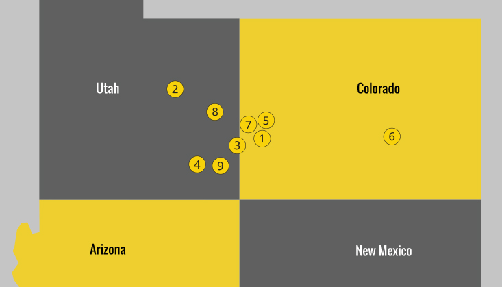
| 1Sunday Complex | 1,007,830 | 0.250 | 6,047,000 | 1.490 | 1,906,081 | 0.360 | 11,436,484 | 2.160 |
| 2San Rafael | 3,404,600 | 0.225 | 4,596,000 | 0.300 | 1,859,600 | 0.205 | 2,510,600 | 0.280 |
| Total | 4,412,430 | 10,643,000 | 3,765,681 | 13,947,084 | ||||
| Historic Resource* | Measured & Indicated | Inferred | ||||||
|---|---|---|---|---|---|---|---|---|
| Projects | U3O8 (lbs) | U3O8 Grade (%) | V2O5 (lbs) | V2O5 Grade (%) | U3O8 (lbs) | U3O8 Grade(%) | V2O5 (lbs) | V2O5 Grade (%) |
| 3Sage | 2,833,795 | 0.220 | 17,829,289 | 1.390 | 181,275 | 0.184 | 1,854,034 | 1.890 |
| 4Farmer Girl | 74,215 | 0.320 | 371,076 | 1.610 | na | na | na | na |
| 5Hansen Taylor | 39,366,000 | 0.061 | na | na | 51,042,000 | 0.058 | na | na |
| 6Dunn | na | na | na | na | na | na | na | na |
| Total | 42,274,010 | 18,200,365 | 51,223,275 | 1,854,034 | ||||
*A qualified person has not done sufficient work to classify the historical estimate as current mineral resources or mineral reserves and the issuer is not treating the historical estimate as current mineral resources or mineral reserves
| Non-Material Properties | Measured & Indicated | Inferred | ||||||
|---|---|---|---|---|---|---|---|---|
| Projects | U3O8 (lbs) | U3O8 Grade (%) | V2O5 (lbs) | V2O5 Grade (%) | U3O8 (lbs) | U3O8 Grade(%) | V2O5 (lbs) | V2O5 Grade (%) |
| 7Van #4 | na | na | na | na | na | na | na | na |
| 8Yellow Cat | na | na | na | na | na | na | na | na |
| Total | na | na | na | na | ||||
Current:
Sunday: "Technical Report on the Sunday Mine Complex Uranium Property, San Miguel County, Colorado, USA” for Western Uranium & Vanadium Corporation Inc., Filed to sedar.com on July 16, 2015, Filed by Western Uranium & Vanadium Corporation Inc, Prepared by Anthony R. Adkins, CPG #8159.
San Rafael: “NI 43-101 Technical Report on the San Rafael Uranium Project (Including the: Deep Gold Uranium Deposit and the Down Yonder Uranium Deposit), Emery County, Utah, USA” for Pinon Ridge Mining LLC, Homeland Uranium Inc. (Utah) and Homeland Uranium Inc. (Canada), Filed to sedar.com on November 20, 2014, Filed by Western Uranium & Vanadium Corporation (formerly known as Homeland Uranium Inc.), Prepared by O. Jay Gatten, Utah Professional Geologist #5222768-2250, North America Exploration Inc.
Historic:
Sage: “Technical Report on Colorado Plateau Partners LLC (Energy Fuels Resources Corporation and Lynx-Royal JC) Sage Plane Project (Including the Calliham Mine and Sage Mine), San Juan County, Utah and San Miguel County, Colorado, Filed to sedar.com on December 21, 2011, Prepared for Colorado Plateau Partners LLC, a Joint venture between subsidiaries of Energy Fuels Inc. and Aldershot Resources Ltd In Compliance with Canadian National Instrument 43-101 “Standards of Disclosure for Mineral Projects”, Prepared by: Douglas C. Peters, Certified Professional Geologist, NI 43-101 Qualified Person, Peters Geosciences, Golden, Colorado.
Farmer Girl: “Amended Technical Report on Energy Fuels Resources Corporation’s Farmer Girl Property, Montrose County, Colorado, Prepared for Energy Fuels Incorporated In Compliance with Canadian National Instrument 43-101 “Standards of Disclosure for Mineral Projects””, Filed to sedar.com on January 26, 2009, Prepared by: M. assan Alief, Certified Professional Geologist, NI 43-101 Qualified Person, Alinco GeoServices, Inc. Lakewood, Colorado, Revised Date: December 16, 2008, Original Date: August 6, 2008.
Hansen/Taylor: Historic resource estimate was originally reported to Black Range Minerals Limited by Tetra Tech in four resource memos (collectively, the Tetra Tech Reports): 1) High Park Kriging Resources – Taylor Ranch Uranium Project, April 25, 2008; 2) North Hansen, Boyer Kriging Resources – Taylor Ranch Uranium Project, April 29, 2009; 3) Technical Memorandum – Boyer, Hansen and Picnic Tree Area Kriging Resources – Taylor Ranch Uranium Project, August 24, 2009; and 4) Technical Memorandum – Boyer, Hansen and Picnic Tree Area Kriging Resources – Taylor Ranch Uranium Project (Updated 2010), August 12, 2010. These memos were originally prepared by Rex Bryan of Tetra Tech, a qualified person under NI 43-101. The results reported in the Tetra Tech Reports are historical estimates under NI 43-101.